Mapping the Lower Northern Neck
The 1608 map by John Smith was drawn with north to the right. It lists the names of many Native tribes living in the Northern Neck. The Cuttatawomen, Wighcocomoco and Meraughtacun names still survive with different spellings. Fleet's Bay appears to be drawn with three creeks instead of four.
The 1670 map by Augustine Herrman and Thomas Withinbrook also orients north to the right. Fleet's Bay is named, but still only appears to have four creeks. Mosquito Point is also labeled with an old spelling. Windmill Point is drawn as more of an island. Dameron Marsh is also noted as Damral's Creek. A 1685 map by Christopher Browne seems to copy most of it's details from the earlier map. The Little and Great Wicomico names both appear and Totuskey Creek is shown further up the Rappahannock.
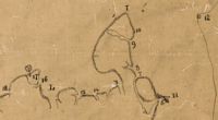
Perhaps one of the earliest and best detailed maps of the shoreline of Lancaster and Northumberland was made in 1736 by William Ball. He states that he completed the survey "In obedience to to awarrant from his Majstis Comissionors" from the mouth of Morattico Creek around the coast to the mouth of the Yocomoco. The map was drawn in pen and ink on a 23"x28" piece of tracing paper and mounted on cloth. Most of the place names given are still in use today. North is oriented toward the bottom left corner. A key was also included on two separate pieces of paper. William Ball was a grandson of William Ball, Burgess and great-grandfather of George Washington.
From the key, H is "Musketo" Point, 12 is "Stingrays" Point, 9 is "Fleet's Island Creek" (Now Little Oyster Creek) and I is Windmill Point. Continuing around to Fleet's Bay, 13 is "the mouth of Nantepoyson Creek," 14 is "the mouth of Tabby Creek," 15 is "the mouth of Fleet's Bay Creek" (Now Dymer's Creek), L is Indian Creek and 17 is "the tree upon Bluf Point." The entry for 20 is, "the dot by it is Dameron's Tobb. house by ? Marsh." Tobb. was most likely an abbreviation for tobacco.
The map that William Ball was ordered to complete was part of a larger effort by Lord Thomas Fairfax to have surveyors in every county bordering the Rappahannock and Potomac Rivers complete boundary maps. Only a handful of those county maps still survive. In 1737 William Mayo assembled all the county maps into one larger map. Some details were lost but he did include four creeks off of Fleet's Bay. Fairfax was displeased with Mayo's map because he thought that it cut him short on land at the headwaters of the Rappahannock. Next he commissioned John Warner to make a map. The Warner maps shows very little detail in the lower Northern Neck. A plantation home drawn near the area of Carter's Creek may have been the seat of King Carter. Warner used the Rapidan river as a southern boundary and greatly increased the size of the claim, much to Fairfax's liking.
A 1755 map made by Peter Jefferson, father of Thomas Jefferson, showed a similar lack of detail but did include home sites for many families including the Balls and Carters. A 1757 French map by Jacques Nicolas Bellin did not even note any roads on the Northern Neck. The 1776 wartime map by the Firm of Robert Sayer and John Bennett in London was also very general.
In the 1814 map by Samuel Lewis and William Hooker the town of Kilmarnock is noted for perhaps the first time. A 1827 map by Herman Boye shows quite a few roads and includes the name Dymer's Creek. Antipoison Creek is not named, but the land making up Windmill Point is labeled as "Nantepoison Neck." The Boye Map was updated in 1859, Antepoison Creek was named as well as Clark's Point. Indian Creek was labeled incorrectly. A Antepoison Beech label also appears. The town of White Stone first appears on a 1862 map and Little Bay is labeled on another map made in 1862 by the U.S. Coast Survey Office during the Civil War. A cross marks the location of Morattico Baptist Church to the northwest of Kilmarnock.


